
The design of systems quickly reveals errors in the perception of the patterns of functioning of the world. Those rules that seem to be immutable truths may not be.
Lists of such fallacies have been compiled pro names or phone numbers. The time has come for maps and navigation systems.
Delusion 1. The shape of the Earth is simply
A sphere is a set of points in space, distant from the center by a distance no greater than the radius. However, at least because of the diurnal rotation, the shape of our planet differs from an ideal sphere. The planet is flattened at the poles and thickened at the equator, and it also has topography and experiences tidal cycles.
You can't get a quick mathematical model here; simplifications are needed. A geoid is a shape of the Earth that coincides with the shape of the World Ocean at complete rest (without the effects of winds and tides) and conventionally extends under the continents. If you dig canals in the continents, connecting the seas, the water level in them will coincide with the geoid.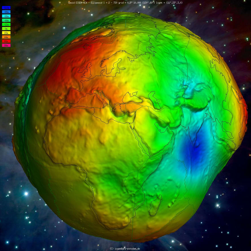
The unevenness of the geoid relative to the reference ellipsoid, scale amplified by 10 thousand times. International Center for Global Earth Models
The geoid is an irregular shape. Even though it is smoother than the real topography of the Earth, the geoid differs from the ellipsoid shape by tens of meters. Therefore, the next step is to select an ellipsoid that will most closely resemble a geoid either on a planetary scale or for some desired fragment. This ellipsoid is fixed at the origin. A model of the Earth is obtained.
Delusion 2. There is one model of the Earth
The parameters of the ellipsoid, including the origin point, form a datum. There are many datums in wide use.
The GPS satellite navigation system, Google Maps and Yandex Maps services are based on the World Geodetic System ellipsoid from 1984 (WGS 84), GLONASS - on the Earth Parameters 1990 (PZ-90), the Chinese BeiDou - on its own derivative of the International Terrestrial Reference System of the era of 2000. An individual U.S. state county may have its own legally significant datum.
Illustration of the need to select the correct coordinates in GPS receivers. Curonian Spit, Baltic Sea coast, map in coordinate system of 1942 (SK-42). Purple points were obtained in SK-42, red - in WGS 84. GIS-Lab
Coordinates in different datums sometimes differ slightly. Sometimes the difference is so great that transformation is required even for domestic purposes.
Misconception 3. Two coordinates will point to a point
According to the giant collision hypothesis, 4.5 billion years ago, a Mars-sized object struck the young Earth. That's how our planet got a satellite - the Moon - and an inclination of rotation.
The axis of the Earth's daily rotation is tilted from the plane of motion of the Earth's orbit around the Sun by about 23° 26' 21". Due to the gravitational effects of the Sun and Moon, this deviation varies from 22.1° to 24.5° and back. The period of this cycle is 41 thousand years, and the deviation value is now decreasing.
NASA
So, the ellipsoid thickened at the equator rotates with deviation. But the gravitational fields of the Sun and the Moon are in the plane of the Earth's ecliptic. Due to this external influence the planet's axis of rotation also changes in space (precession). This cycle takes 25.7 thousand years, while the axis slightly wobbles (nutation).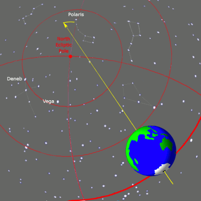
Because of the precession cycles of equinoxes (precession cycle) every stellar year the vernal equinox occurs slightly earlier than in the previous year - about 20 minutes earlier. The daily rotation of the Earth is given here not to scale: in reality, the planet will make more than 9 million revolutions. Tfr000
Also, the Earth is impermanent. The continents are drifting, and the magnetic field is changing. These processes are slow, but their speed is also unpredictable. If somewhere above with a reference to the site of the Earth rotation service is given a constant, it does not mean that this value will not be clarified in twenty years.
Because of changes and refinements in the Earth's parameters, datums are regularly updated. But some remain in use for decades. For example, Soviet and Russian maps may be made using SC-42, U.S. maps come in the 1927 NAD27 standard, and some Norwegian oilers still rely on ED50. Offsets from a modern GPS receiver in WGS 84 on such maps will be hundreds of meters.
In addition to the coordinates, you need to specify the datum and its epoch.
Misconception 4: Coordinates are latitude and longitude in degrees
In 1980, Texaco was drilling a new field in Lake Peñor. Exploration indicated that there should be a pocket of oil under the bottom of the lake, somewhere near the Diamond Crystal Salt Company salt mine. The plan called for a drill within 15 meters of the salt mine. Diamond Crystal gave Texaco a detailed map of the mine - technically it was all feasible.
On the morning of November 20, the drill suddenly got stuck in the crystallized salt, which was estimated to be another 30 meters away. The drill penetrated the ceiling of the mine and the water rushed down from the lake. The whirlpool sucked in the rig, eleven barges, the tugboat, the dock, the island with the botanical garden, houses, and trucks.
The Texaco engineer misunderstood the map provided: it used rectangular coordinates, not degrees. Such maps are marked with a coordinate grid with kilometer lines.
The universal transverse Mercator projection (or, if the map is Soviet, Gauss-Krueger projection) divides the entire surface of the Earth into 60 zones 6 degrees wide and extending in the meridional direction. In each zone, the coordinates are given as the deviation to the east and to the north in meters (or feet if we are talking about the USA).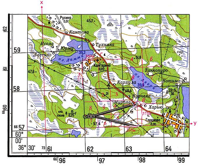
Here is an example of a problem in which you want to measure rectangular coordinates using a linear map scale. The coordinates of point B are: X = 6657000 + 575 = 6657575 m, Y = 7363000 + 335 = 7363335 m.
Do not be surprised by the large numbers in the coordinate entry field.
Misconception 5: Latitude is first, longitude is second
The common order is "latitude, longitude", but some systems use the order "longitude, latitude". An example of the second is the GeoJSON format (enshrined in the standard, RFC 7946, paragraph 3.1.1).


